Muhtasari wa jiolojia ya Africa Mashariki kwa maneno yasiozidi 1,000.
(A huge thanks to Prof. Andy Nyblade, Professor and Department Head, Department of Geosciences from Penn State University for reviewing this piece).
There are a few important processes and events that we need to understand if we want to interpret geological features in our landscapes. The first is to understand the forces that have formed continents and are continuing to move them around. The second is to understand how rocks form. Finally, we need to look back through time and try to picture what was happening in the past.
It is difficult to talk about geology without getting theoretical, but in order to understand what is happening we need to imagine blocks of rock floating around on a thick fluid of melted rock. The movement of the fluid rock moves the floating blocks of rock around and sometimes the collide and push up against each other, sometimes they slide past each other, and sometimes they get pulled away from each other. We call these blocks tectonic plates and they make up the different continents. Here is a great little video that explains it in cartoon form.
Now that we have established how the blocks move around let’s look at how rocks are formed. The simplest and fastest way that rocks can form is from cooling of liquid rock in the form of magma or lava. We call these igneous rocks. This can happen in the form of a volcano or it can happen under the surface of the Earth.
Another way that rocks form is by sedimentation. Sediments are particles of sand and soil that get washed into lakes or under the sea and accumulate in layers. Sediments can also be made up of materials that come from living things for example the skeletons of coral, plankton, or even plants. If enough of these sediments accumulate, they can be transformed into rock by the pressure of their own weight.
The third way rocks form occurs when sedimentary rocks or igneous rocks are changed into a different form usually because of high pressure or heat. This usually happens when two blocks of rock push together forming a mountain range such as the Himalayas or Alps. It can also happen when magma pushes up into the crust and heats the rocks. We call these metamorphic rocks. Most gem stones are formed during the metamorphic process.
Geological history is made up of alternating cycles between big mountain building events caused by tectonic plates pushing against each other, and times of pulling apart and erosion. The time scales are often in the hundreds of thousands to hundreds of millions of years.
The oldest rocks we find in East Africa make up cratons. A craton is an old piece of continental crust that is tectonically stable. Sub-saharan Africa as we know it know, is made up of three old cratons- the Congo craton and Southern African craton which are massive, and then a smaller craton called the Tanzania craton. The oldest rocks in the Tanganyika craton are about 2.9-3.0 billion years old and took a billion years to form.
About 2.1 billion years ago an oceanic plate pushed up against the Tanzania craton on the East side forming a subduction zone and creating mountains like the current Andes in South America. This was called the Usagaran belt. Most of these mountains eroded, and many of these foundational rocks became further changed during another mountain building event more than a billion years later. Subduction zones are known for having volcanic activity and metamorphic change and so this area has a variety of different rock types from granites, old lavas, and sedimentary rocks that were pushed up.
Around the same time, the Tanzania craton was pushing up on the Congo craton. As they pushed together they lifted up the sedimentary rocks at the bottom of the ocean to create a chain of mountains known as the Ubendian belt, forming a a belt of the rocks along the west of Tanzania, extending into Malawi.
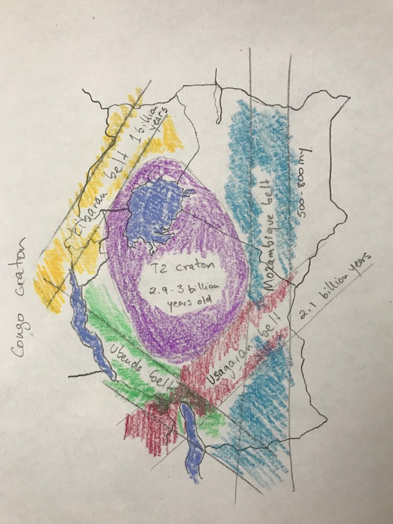
As the forces relaxed, the Tanzania craton pulled apart from the Congo craton and formed a deep valley which filled with sediment. Then about 1 billion years ago the Tanzania craton started pushing up against the Congo craton pushing all of the sediment and creating a mountain range called the Kibaran range which makes up most of the hills of Rwanda.
The next major geological event occurred when Madagascar and India pushed up against the African continent. Again, this pushed up the sediments from in the ocean and created one of the longest and tallest mountain ranges in the world. This range is called the Mozambique belt. To put it into perspective it took 350 million years for this mountain range to form. This event also changed many of the Usagaran rocks and mountains.
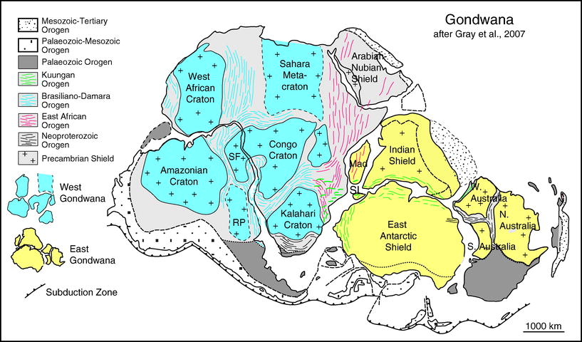
Source: Meert J.G. (2011) Gondwanaland, Formation. In: Reitner J., Thiel V. (eds) Encyclopedia of Geobiology. Encyclopedia of Earth Sciences Series. Springer, Dordrecht. https://doi.org/10.1007/978-1-4020-9212-1_92
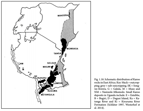
Then after a few hundred million years the continents pulled apart again. At this point Madagascar, India, and Antarctica pulled away creating a major rift valley that eventually became the Indian Ocean. Erosion filled some of the rifts and basins that formed with sediments. These sedimentary rocks have become known as the Karoo and are found in many places across eastern and southern Africa.
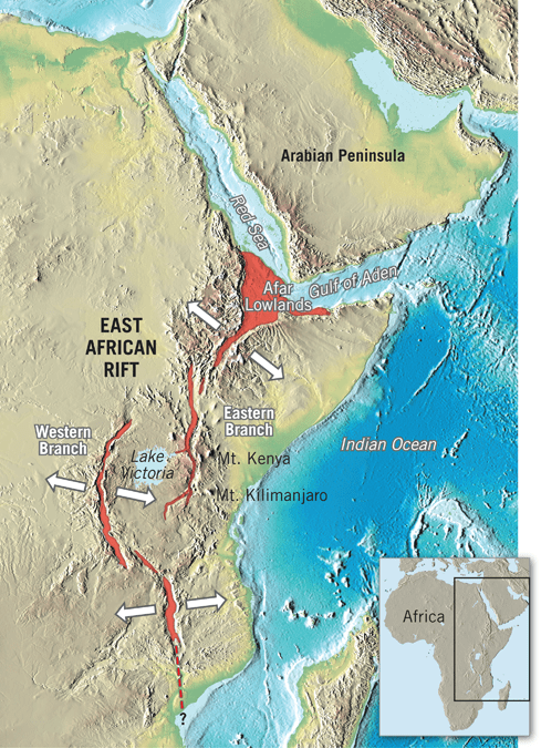
About 30 million years ago, another phase of extension began, which led to the development of the East African rift system. Occasionally the magma pushed through the surface and create volcanoes. The cracks followed old weaknesses spliting into two arms, one travelling around the west side of the Tanzania craton opening up what we call the western rift. The other arm followed the east side of the craton through the Mozambican belt, and is called the eastern rift. The cracking is far from simple and creates some interesting rifting features including volcanoes, rift valley lakes, and escarpments which we will get into on another day.
https://storymaps.arcgis.com/stories/52910977b1684a348a350bc1c78394ce
Swahili version
Kabla ya kutafsiri sehemu mbalimbali ya kijiolojia tunahitaji kuelewa harakati na matokeo nyeti. Ya kwanza ni kuelewa nguvu zinazozitengeneza bara na kuendelea kuzisogeza. Cha pili ni kuelewa namna mawe yanavyotengenezeka. Mwisho, tunahitaji kuangalia urefu wa historia na kujaribu kusimulia kilichotokea zamani.
Ni ngumu kuongea kuhusu jiolijia bila kutumia msamiati ya kiufundi na kubuni kinadharia, lakini ilikuelewa kinachotokea tunahitaji kufikiria miamba yanayoelea juu ya mawe yalioyeyuka kwa moto kali yakiwa majimaji kama asali. Miendo ya haya mawe yaliokuwa majimaji yanasogeza miamba yalioelea juu yake na mara kuyakutanisha, mara kutenganisha, na mara kusogeleana. Sahani za mawe tunaziita miamba mikuu (‘tectonic plates’) na ndiyo yanatengeneza bara tofauti duniani. Hapa kuna video nzuri linaloonyesha kwa katuni.
Kwa vile tumeelewa sasa kuhusu msongamano wa haya miamba mikuu, tuangalie mawe yanatengenezwaje. Namna haraka na rahisi kutengeneza jiwe ni kupooza mawe yaliyokuwa majimaji kwa njia ya magma au lava. Haya mawe yanaitwa mawe aina ya ‘igneous’. Haya mawe yanaweza kutokea kwa volkano au yanaweza kutokea chini ya sura ya ardhi (miamba yalioelea juu ya mawe ya majimaji).
Harakati nyingine ya kutengeneza mawe ni kwa masimbi. Masimbi ni vipande vidogo vya mchanga na udongo vinavyokusanywa na maji kwenye ziwa na china ya bahari na kuwekwa kwa tabaka. Masimbi yanaweza kutokana na mili ya viumbe hai kama viunzi vya matumbawe, planktoni, na hata mimea. Masimbi yakikusanyika ya kutosha yanaweza kubadilika kuwa mawe kwa kugandamizwa na uzito wao yenyewe.
Namna ya tatu ya utengenezaji wa mawe ni kwa mabadiliko ya haya mawe ya masimbi au ‘igneous’ kwa mgandamizo mkubwa au joto kali. Mara nyingi hutokea wakata miamba kuu inasukumana na kutengeneza milima kama Himalaya au Alps. Inaweza ikatokea pia wakati wa ‘magma’ (mawe ya majimaji) kusukuma kutoka chini ya miamba na kupenya na kupasha joto mawe yaliyopo. Haya mawe tunayaita ‘metamorphic’, yaani ‘yaliyobadilika sura’. Madini mengi yanatengenezwa wakati huu kwa ‘metamorphism’.
Historia ya kijiolojia imeungwa kati ya mizunguko ya muda za kutengeneza milima wakati miamba mikuu inasukumana, na wakati mwingine wa mimonyoko miamba mikuu ikitenganishwa. Wakati unaohusika mara mingi ni kati ya miaka milaki hadi mamilioni.
Tunakuta miamba ya zamani zaidi hapa Afrika Mashariki ni ‘craton’. ‘Craton’ ni kipande cha bara nene na yenye uimara sana. Hapa kusini mwa jangwa la Sahara kuna ‘craton’ tatu kuu- ya Kongo na ya Afrika Kusini ambazo ni kubwa sana, na craton ya Tanzania. Miamba kwenye ‘craton’ ya Tanzania yana miaka bilioni mbili nukta tisa hadi bilioni tatu, na yalichukua muda wa karibia miaka bilioni mmoja kutengenezwa.
Karibia miaka bilioni mbili nukta mmoja iliyopita, mmojawapo wa miamba kuu ya bahari ilianza kusukumwa kwenye upande wa mashariki wa craton ya Tanzania. Sehemu ilipokutanishwa ikasababishwa aina ya ‘subduction’ (mwamba kwenda chini ya mwamba mwingine) na ilitengeneza milima mirefu zaidi kama milima ya Andes ya Amerika Kusini. Milima hiyo iliitwa mkanda wa Usagara. Milima hiyo imeporomoka na baadhi ya miamba kwenye mkanda huu ilibadilishwa tena kwenye tokeo la kujenga milima mingine karibia miaka bilioni moja badaye.. Maeneo ya ‘subduction’ (miamba kuzama chini ya mingine) yanajulikana kuwa na volkano pamoja na mawe yenye mabadiliko ya ‘metamorphism’ na ndiyo maana kuna aina nyingi za miamba kuanzia ‘granite’, ‘lava’ za zamani, na miamba ya masimbi iliyosukumwa na kuinuliwa juu.
Ni watakati huo huo, ‘craton’ ya Tanzania ilisukumwa kwenye ‘craton’ ya Kongo. Wakati ziliposogeleana zilinyanyua miamba ya masimbi kutoka chini ya bahari na kutengeneza mkanda wa miamba yanayojulikana kama mkanda wa Ubende. Ni miamba aina hiyo inapatikana upande wa magharibi wa Tanzania hadi Malawi.
Wakati nguvu ilipopungua, ‘craton’ ya Tanganyika ilianza kuachana na ‘craton’ ya Kongo na kutengeneza bonde lililojaa na masimbi. Karibia miaka bilioni moja iliopita, ‘craton’ ya Tanzania ilianza kusukuma ‘craton’ ya Kongo tena na kuinua miamba ya masimbi ikatengeneza mkanda wa milima ijulikanayo kama Kibara. Ndiyo miamba sehemu kubwa wa milima ya Rwanda.
Tokeo kubwa ya kijiolojia yaliotokea baada ya hapo ni wakati bara la Madagaskar na ya India zilizoanza kusukumia bara la Afrika. Tena, masimbi ya kutoka chini ya bahari yalisukumwa na kunyanuyuliwa kutengeneza mkanda wa milima yaliokua refu na kubwa duniani kwa wakati ule. Haya milima yanaitwa mkanda wa Msumbiji. Kuiweka kwenye mtamzamo unayofaa, ilichukua karibia miaka milioni mia tatu hamsini kuyanyanyua haya milima. Hii tokeo ndiyo ilibadilisha miamba ya Usagara.
Baada ya miaka milioni mia kadhaa, bara zilanza kutenganishana tena. Ni kipindi hiki bara la Madagascar, India, na Antarktika ziliachana na kutengeneza bonde la ufa kubwa sana kilichojaa maji na kutengeneza Bahari ya Kihindi. Mimomonyoko ya ardhi yalijaza baadhi ya mabonde mengine na kuyajaza na masimbi. Haya masimbi yanajulikana sana kama miamba ya ‘Karoo’ na yanapatikana zaidi kwenye maeneo mbalimbali katika Afrika mashariki na kusini.
Karibia miaka milioni thelathini iliopita, kipindi cha utenganishaji mwengine ulianza na ndiyo ulisababisha Bonde la Ufa la Africa mashariki (East African Rift System). Mara kwa mara magma ulipenya kwenye miamba na kujitokeza kama volkano. Huu mchaniko ulifuata sehemu dhaifu kama viungo vya zamani, na iligawanyika, upande mmoja ulizungukia upande wa magaribi na kutengeneza bonde la ufa wa magharibi. Upande wa pili, ulifuata mkutanisho wa mkanda wa Msumbiji na ‘craton’ ya Tanzania, na ndiyo inaitwa ufa wa mashariki. keo hili la kuchanika na kuachana siyo kitu cha kirahisi na kilitengeneza maumbo mengine ya ajabu kama volkano, visiwa vya bonde la ufa, na milima ya kiwimawima tutakayoiongelea wakati mwingine.
Sources:
Brick, R. A. 2011. Paleoproterozoic eclogite formation in Tanzania: a structural, geochronological, thermochronological and metamorphic study of the Usagaran and Ubende orogenic belts. University of Adelaide.
S. Muhongo, H. Fritz, V. Tenczer, C. A. Hauzenberger, A. Mogessie, E. Wallbrecher, and G. Hoinkes. Central Tanzanian tectonic map: A step forward to decipher Proterozoic structural events in the East African Orogen. TECTONICS, VOL. 24, TC6013, doi:10.1029/2005TC001796, 2005
Chrowicz, J. & Daly. M. Rift basin evolution in Africa: The influence of reactivated steep basement shear zones. Article in Geological Society London Special Publications · January 1989 DOI: 10.1144/GSL.SP.1989.044.01.17
Morley. C. K. Developments of the structural geology of rifts over the last decade and their impact on hydrocarbon exploration. Department of Petroleum Geology, University of Brunei.
Kazimoto, E. D. Schenk, V. Berndt, J. 2014. Neoarchean and Paleoproterozoic crust formation in the Ubendian Belt of Tanzania: Insights from zircon geochronology and geochemistry.
Neoarchean and Paleoproterozoic crust formation in the Ubendian Belt of Tanzania: Insights from zircon geochronology and geochemistry. Elsevier. http://dx.doi.org/10.1016/j.precamres.2014.06.020
Scoon, R. N. 2018. Geology of National Pakrs of Central/Southern Kenya and Northern Tanzania. Springerlink.
Categories: Uncategorized

Aisee nafurahi sana kujifunza historia ya miaka bilioni 3 ndani ya maneno elfu moja tu. Nashukuru sana Mwalimu
LikeLike